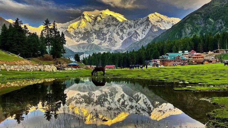
Rakaposhi (7,788 m) is the 27th highest mountain in the world. In Pakistan, it is ranked the 12th highest. In the local Baltistan language, Rakaposhi means “Snow Covered”. Another meaning of the mighty mountain is “Mother of the Mist”. It is so broad peak that stretches 20 km from East to West. Surprisingly, it is the only mountain, which drops 6,000 meters straight from the summit to the base. There are only 3 routes to climb the mountain. In the local Brushushki language, the mountain means “Shinning Wall”.
Rakaposhi is too difficult and complicated to be climbed. Routes from the Western side are too long, from the Northern direction too high, and technically difficult. Whereas, southern and eastern routes are quite dangerous because of the maximum avalanche risk. However, in 1958 Tom Patty and Mike Banks of a British-Pakistani Expedition first climbed the peak via the Southwest Spur/Ridge Route. The endeavor got a success after various futile attempts.
Dumani (“Mother of Mist”)
Rakaposhi expedition offers the perfect view of multiple mountains. The fabulous view of the Karakoram Range can be enjoyed from this mountain. The climbers of Rakaposhi experience the scenic Hunza Valley of Gilgit Baltistan. Moreover, the aspirants of the Rakaposhi Expedition can explore the historic Silk Route i.e. Karakoram Highway.
It is a pertinent point to be noted that Rakaposhi is not an easy mountain to be climbed. The trekking of this peak could be much arduous and painstaking. One should be iron-nerved and patient for this task. The attitude of the climbers is needed to be flexible. Stubborn and irritant persons are not fit for this activity. Moreover, teamwork is a key to success during this journey. Plans may be altered all of a sudden, snow storm may create a halt, and other technical implications may prolong the journey. In short, every sort of problems are expected to occur. Therefore, resilient aptitude is the demand of expedition.
Itinerary of Rakaposhi Expedition
Arrival in Islamabad
Most of the International flights land at the Islamabad International Airport. Foreign visitors have to land at the Airport. The local aspirants too have to reach here. After some rest, the concerned company provides a briefing about the Journey. The luggage is checked and confirmed at the hotel. If time is available, there might be some sightseeing at the beautiful and promising city of Islamabad. The city was built in 1961 on magnificent Margla Hills. Its weather, aura, atmosphere, greenery, tall trees, State Buildings and behind all of them the hills; albeit everything is worth seeing.
Islamabad to Chilas
On the second day, the tourists start the travelling towards Chilas on Karakoram Highway. The epic cities of Hassan Abdal, Taxila, Hari Pur, Abbot Abad, and Besham. Karakoram High Way actually starts from Hassan Abdal. The route passes by the mighty Indus River. As it is the 8-hour long route of 41 km, tea breaks on the way should be taken. Chillas are almost 190 km. it is a quite serene destination. Three gorgeous mountain ranges of the world can be viewed from Chillas: the Hindukush Range in the west of Chillas, the Himalayas in the East, and the Karakoram Range in the North. The view is so fantastic. Moreover, Chillas is the gateway to the Killer Mountain Nanga Parbat.
Towards Minapin (220 km)
On 3rd day, the journey is started towards Minapin. This 22o km long route is covered in 7 hours. The tourists travel along the Indus and Hunza Rivers. The superb view of Nanga Parbat from Karakoram Highway is indescribable in words. The route is covered with apple, apricot and walnut trees, which look awesome either in autumn or Blossom. Minapin is a small village. From this point the Rakaposhi and Diran base camps start. Moreover, the tourists have a stunning view of Rakaposhi mount which color is altered with twilight.
Trek to Tagafari (3,700 m)
On the 4th day, the trek from the village starts towards the Minapin River. 15-minuteutes trail is on a tree-covered Canal. What a pleasant trek! This tree-covered trail reaches the grassy meadow Hapakun. From this Meadow, Hachinder and Maiun peaks above the Hunza River can be viewed. The trial accomplishes at Tagaphari. From this point, the Rakaposhi, Diran, and their interlinking ice fall is easily viewed. Night stay at Tagaphari is in camps. Full services and facilities are provided at the campsite. Balti, Desi, and local foods are served to the tourists.
Trek to Rakaposhi Basecamp
On 5th day, the trekkers head towards Rakaposhi base camp. This 3900 m trek is a fabulous experience. From Tagafari to Rakaposhi, the trekkers walk for 3 hours on land and 3 hours crossing of Mianpin glacier. At last, they reach Darin. From this base camp, the trekkers head towards the final point. Various mountain peaks are viewed from here.
Acclimatization and Climbing days to Rakaposhi
From the 6th to the 35th days is the period of acclimatizing and climbing the Rakaposhi basecamp. The staff of the relevant company guides and assists the trekkers. Some trekkers arrange the cooking of meals. A healthy and delicious diet plays a significant part in climbing.
Trek to Tagafari
After the marvelous experience of climbing the gigantic Rakaposhi, the trekkers on the 36th day head back towards Tagafari. This 4 hours walk is again an awesome journey.
Trek to Minapin
On the 37th day, the adventurists start a 7-hours walk up to Minapin.
Drive to Chillas on the 38th day
Drive to Islamabad on the 39th day
Departure and fly back to Homes
Weather Condition in Rakaposhi
During summer, the weather remains normally pleasant. Yet, snow storms at any time can turmoil the journey. From June to August, the temperature remains between 25 to 30 degrees. However, after 4,000 meters in height, there may be freezing temperatures at camps. Might be Minus 10 degrees at night. The trekkers must have the necessary equipment to embrace the sudden change in weather conditions.
The aspirants of this expedition have to confirm all the expenses and fairs of accommodations, transport, and meal from the concerned company. As the economic condition of Pakistan is unstable. The expenses may fluctuate. The climbers are advised to not rely on the previous rates.


